This next expedition was set to head to Emerald Pools, one of Oregon’s best swimming spots, along with a good place to find interesting rocks. Talking to a good friend, Ladell, we’ve discussed perspectives and methods of collecting resources along with sustainability, waste management, and geology. His perspective and way of thinking piqued my interest.
Soon later, I used apps like Rockhound, Gaia, and AllTrials Learning, stating, “Crooke County is the biggest hounding location in the world.” Crooke County is about another 130 -150 miles further past emerald pools. Curiously, I called one of my friends who recently moved from Salem, OR, to see where he now resided. It turns out he lives in Prineville, which is a part of Crooke Co. I told him I was coming to visit, which is about 200 miles away. He asked, “How are you getting here”. I quickly responded that I was walking. Being a marine vet, he suggested meeting me somewhere along the way and asking that I tell him when I leave. Even though it will probably take me two to three weeks, he wants to know when I will start. Jokingly, I agreed and said he had better get ready soon. I hope to introduce him to one of the new websites just made; just make Podbean or/and YouTube and embed it on WordPress.
Preparing for this trip I am doing a lot of research preparing my route. With Gaia maps I am able to make waypoints and a route. I noticed the hiking trails connect on the way to Crooke Co., but go every way except straight. Walking this route suddenly became unappealing. Reflecting on being a nomad and interest in miscellaneous adventures I wondered why am I organizing it this way and can I do it more from the cuff? I have spent many hours reviewing but hiking trails, waterways and other things of interest mainly rockhounding locations and begun to prepare for a much different trip. The goal is to eventually end up in Prineville or start my adventure from there.
People ask when will you get back. I really do not know. I am unsure, but something I am considering for my way back is taking a canoe or kayak back from Cottage Groove to Salem on the Willamette scenic river. If I go this route I would probably find a cheap canoe on craiglist someone down in southwest Oregon and find connecting bodies of water to get to the Willamette river. This is on the opposite side of the state so getting there is still to be determined as well.
Crooke Co and many surronding areas are good for rockhounding. I was waypoints on my Gaia map for great locations trying to figure out a good route to hit as many of them as possible at a good pace. There is a lot of national parks and hiking trails in north east OR, which pulls me to start the expedition out there. In the top right corner of OR inflows the snake river. If I can get a boat and start up there then float down snake along the Idaho and OR coast. One of the top scenic areas here is the Hells canyon. It looks beautiful from the pictures. “Hells Canyon is significantly deeper than the Grand Canyon, reaching a depth of about 7,993 feet”. Eventually I would ditch the boat and hike west towards Crooke Co hopefully hitting and amazing rockhounding route. I have looked at some of the pictures along a the way seeing blue butte, red bed and many other butte’s all explained to be great places to find cool rocks. Here is a picture found online for the blue butte below.
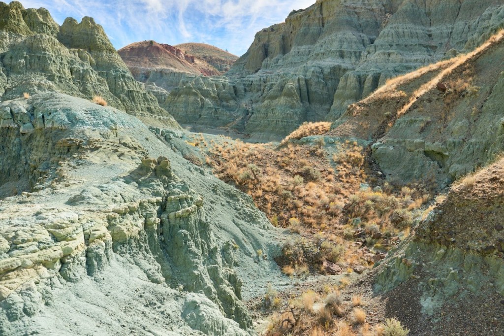
I think it looks really cool. There are so many places in this area just as cool as this area. Fingers crossed in finding a blue lightening rock. Thanks to Jonnie Richardson and his family I was able to review areas mentioned on there family business website. From what I understand this family resides at the Richardson’s rock ranch. I will be reaching out to this family soon via email to hopefully get an interview and to check out all the cool rocks. Maybe they would even consider my services as an engineer. Maybe telling them Grandma Lindberg was a rock cutter will help break the ice. Here is a link to that site if you want to learn more:
Native American History is one of my favorite history subjects to study in the US. While reviewing the Richardson’s website I came across a legend told from long ago.
According to legend, Thundereggs were so named by Native Americans of Central Oregon. The natives of this region are said to have believed these strange, agate-filled stones were missiles thrown by angry, fighting “Thunder Spirits” or “Gods” who dwelt on Mount Jefferson and nearby Mount Hood, two of the several snow-capped peaks high in the Cascade Range. The Native Americans thought when thunderstorms occurred these rival, jealous gods hurled large numbers of the round-shaped rocks at each other in furious anger. Thus, according to Native American legend, Thundereggs were scattered over the high plateaus of Central Oregon
I am preparing to leave for this trip and waiting for backpacking supplies to come in the mail hopefully before Tuesday. I have a few microcontrollers projects for this trip and Isaac community garden that will need to be set up hopefully over the weekend. One of the things in the mail is a lightweight portable solar panel and charger. The charger takes AA and AAA so I figure these batteries can be used as battery packs for my Arduino projects. I was thinking about doing some environmental science experiments and figuring out how and where to log it. I am also interested in finding precious metals so a sensor or sensors needs to be selected for data sample on that end as well . One rapid prototype I’ve wanted to make for a while is the autonomous snare trap. I would have a snare that is trigger for example by an objects distance to am ultra sonic range finder sensor. Using a microcontroller for this might be overkill. I need to do more research to figure out if I can build the system with a relay apparatus. The electrical parts minus the power source if just IC (Integrated Circuits) are use cost might be less than a dollar if bought in bulk. It looks like the lightest range finder is about 4 grams. It looks like the NE555P IC weights about 0.9 grams. This equipment would not take up much room in the bag.
The problem with the arduino is I need an Arduino IDE (Interactive Development Environment) platform to load the code onboard, which can not be done by phone. So I would have to have like a pc or something. However, I just checked there are apps that can load code onto arduino from phone. Later on I hope to get a souped up computer for nomadic coding at such, but have to remain humble for now. A lot of my gear is outdated and old, which reminds me to not try anything to crazy, but soon I think I will be prepared to get on the PCT (Pacific Crest Trail). It is much colder up there and do not have the setup for it yet. Although I do have good boots, but I am still skeptical. It would be nice to not be absolutely dreadful the entire adventure haha. I’m hoping to get a hold of some retailers after this expedition to see about starting some partnership’s. I think i’m along ways from getting sponsored by Red Bull. You have to do some pretty crazy stuff to get sponsored by them. Maybe i’ll save that sponsorship pitch for when I go to the amazon to wrestle an anaconda only partly joking. Tonight I need to gut out my phone and clean it. The install peripherals and cpu into the new housing module. If that works out the rockhounding route should be ready to be on point. Cheers
